Contents:
-
Core Capabilities: What to Expect from Location Intelligence Platforms
-
The Missing Layer: Integrating Workforce Intelligence into Location Strategy
-
Understanding Growth with Data-Driven Location and Talent Decisions
Key Takeaways:
1. Location tools were built for customers, assets, and routes, not for talent. Across the seven platforms reviewed, none treats labor market data as a first-class layer. They can show where demand is, but not how many qualified cloud security engineers live within commuting distance of a candidate site, what they earn, or who else is hiring them. Without that, a shortlist built on rents, tax incentives, and drive times can fail when 150 roles can’t be filled at the budgeted salary bands. A city that ranks third on real estate cost can rank first once time-to-hire and salary pressure are included.
2. Ease of use and analytical depth trade off, so match the tool to the decision. Salesforce Maps and Geopointe are easy for recruiters and HR partners but too shallow for site selection. ArcGIS and CARTO can answer it but need specialists. Precisely fixes input data quality, Maptitude offers value, and Mapbox is building blocks for custom tools. If most of your decisions are talent-led, a route optimization engine is a cost you won’t use. Also check data coverage country by country, since demographic depth in the US and Western Europe rarely matches Southeast Asia, Latin America, or Eastern Europe.
3. Count total cost of ownership and test on a decision you’ve already made. License fees are often under half of what you’ll spend once you add third-party data licenses, consumption charges at production volumes, integration work, a GIS analyst or data engineer, and retraining. Usage-based pricing looks cheap in a pilot and can climb sharply in production. Re-run your last site selection in a trial: if the platform wouldn’t have flagged the talent shortage that slowed your last expansion, it won’t flag the next one. Weight data quality and coverage highest, and involve talent acquisition, not only the analytics team.
—---------------------------------------------------------
Enterprises regularly choose a new hub based on lease rates, tax incentives, and drive times, then discover a year later that they cannot fill 150 engineering roles there at the salary bands they budgeted.
The challenge is that location decisions rarely sit within a single function. Real estate, finance, operations, and talent acquisition each bring different priorities to the table, and the software used to evaluate a site needs to account for more than geography alone.
Below, we review seven top-rated location intelligence software platforms, compare their mapping software capabilities, break down what they actually cost to own, and show where workforce data has to enter the decision before anyone signs a lease.
The Strategic Value of Location Intelligence Software
Location intelligence software answers one question in many forms: where should this activity happen? For a retailer, that means which trade area supports a new store. For a logistics team, it means which warehouse placement cuts last-mile cost. For a CHRO, it means which city can actually supply the people a new center of excellence needs.
Modern location intelligence platforms combine several data streams that used to live in separate spreadsheets: geospatial boundaries, census and demographic data, foot traffic, competitor locations, transport networks, and internal business records like sales or headcount. Once those layers sit on the same map, analysts can run scenarios instead of debating anecdotes. A finance lead can see what moving a distribution center 40 miles inland does to delivery windows. A sales leader can redraw territories, so reps spend more hours with customers and fewer hours driving.
That is where the workflow gains come from. Teams stop rebuilding the same analysis every quarter, and decisions that once took a consultant engagement can be tested in an afternoon.
Most location planning tools were built for customers, assets, and routes. They are excellent at telling you where demand is. They are much weaker at telling you where talent is, what it costs, and how fast you can hire it.
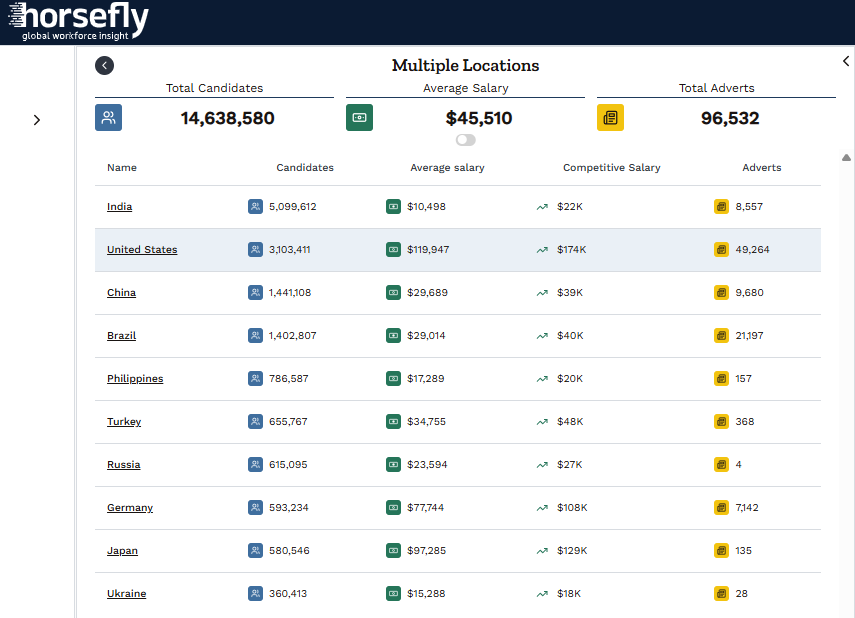
A view of Location data from Horsefly
Core Capabilities: What to Expect from Location Intelligence Platforms
We group the capabilities into four buckets. Few platforms excel at all four, so knowing which bucket matters most to you narrows the field quickly.
Geospatial analysis and data visualization
This is the baseline: geocoding addresses, layering datasets, and rendering results as heat maps, choropleths, drive-time polygons, and territory boundaries. Strong geospatial data analysis goes further, with spatial joins, clustering, hot spot detection, and catchment modeling. Ask vendors whether analysis runs on your full dataset or on a sample. Many browser-based tools quietly cap the number of points they render, which distorts results when you are mapping hundreds of thousands of records.
Site selection and optimization
Site selection tools combine demographic data (population, income, age, education), points of interest, competitor locations, and sometimes mobile foot-traffic data to score candidate sites. The better platforms let you build a weighted scoring model, test it against your existing high- and low-performing locations, and then apply it to new markets. The weakness to watch for is data coverage. Demographic depth in the US and Western Europe rarely matches what is available for Southeast Asia, Latin America, or Eastern Europe, and that is exactly where many enterprises are expanding.
Logistics and mobility
Route optimization, fleet management integration, and territory management belong here. These features matter enormously to field sales and service organizations and very little to a team deciding where to open a shared services center. Do not pay for a logistics engine you will not use.
Integration and extensibility
API capabilities, native connectors to CRMs and data warehouses, and support for custom data imports determine whether the platform becomes part of your planning process or a standalone tool one analyst uses twice a year. If your HRIS, ATS, and finance data cannot flow into the platform, workforce scenarios will always be manual. Integrating location data with existing business intelligence systems also helps teams assess sites using a consistent evidence base.
Review: Top Location Intelligence Software for Enterprises
1. Esri ArcGIS
Key features: ArcGIS Pro for desktop analysis, ArcGIS Online for cloud sharing, and ArcGIS Business Analyst for site selection with licensed demographic and consumer spending data. The spatial analytics toolset is the deepest on the market, covering network analysis, suitability modeling, and spatial statistics.
Primary strength: Best for deep spatial analysis. If a geospatial method exists, ArcGIS almost certainly supports it.
Notable weaknesses: Steep learning curve. Most organizations that get real value from ArcGIS employ trained GIS analysts. Licensing is layered (user types, extensions, and consumption credits), which makes budgeting harder than it should be.
Ideal user: Global enterprises with a dedicated GIS or location analytics team and complex, multi-use requirements across real estate, operations, and planning.
Pricing model: Named-user subscriptions by user type, add-on extensions, and credit-based consumption for certain analyses and data.
2. CARTO
Key features: A cloud-native location intelligence platform that runs analysis directly inside your cloud data warehouse rather than copying data into a separate system. It includes spatial SQL functions, a visual workflow builder, and a data catalog of third-party datasets.
Primary strength: Best for organizations whose data already lives in a modern cloud warehouse. Processing large datasets where they sit avoids duplication and keeps governance simpler.
Notable weaknesses: It assumes a mature data stack. If your HR and operational data is scattered across on-premise systems, you will spend months on plumbing before you see results. Business users without SQL skills depend on the data team.
Ideal user: Data-mature enterprises with analytics engineers who want spatial analysis integrated into existing BI and data science workflows.
Pricing model: Annual subscription, tiered by users and usage, with third-party data licensed separately.
3. Salesforce Maps
Key features: Native mapping inside Salesforce, with territory planning, route optimization, scheduling, and live tracking for field teams. Data stays in the CRM, so maps reflect current accounts and opportunities.
Primary strength: Best for sales and field service organizations already standardised on Salesforce. Adoption is easier because reps never leave the system they work in.
Notable weaknesses: It is a CRM mapping tool, not a general-purpose spatial analysis platform. Site selection depth is limited, and it offers nothing meaningful for workforce or labor market analysis.
Ideal user: Enterprises managing large field sales or service teams on Salesforce.
Pricing model: Per-user, per-month add-on to existing Salesforce licenses, with higher tiers for advanced territory and routing features.
4. Precisely
Key features: Address validation, geocoding, location data enrichment, and a large catalog of curated datasets, including property attributes, points of interest, boundaries, and demographics. It is often embedded in other systems rather than used as a standalone map.
Primary strength: Best for data quality. If your location decisions fail because addresses are wrong or records cannot be matched, Precisely fixes the input layer.
Notable weaknesses: Limited as a front-end analysis tool for business users. You typically pair it with a visualization or BI platform, which adds cost and integration work.
Ideal user: Large enterprises in insurance, financial services, telecom, and retail with heavy data governance needs.
Pricing model: Enterprise licensing, typically negotiated by data product, volume, and deployment.

Review: Leading Solutions for SMBs and Specific Use Cases
5. Maptitude
Key features: Desktop GIS software from Caliper that bundles extensive demographic data, territory mapping, drive-time rings, and routing in a single install.
Primary strength: Best value for money. You get a capable GIS with built-in data at a price that small businesses and departmental teams can approve without a procurement cycle.
Notable weaknesses: Desktop-first design makes collaboration awkward, and the interface feels dated next to cloud tools. International data coverage varies by country package.
Ideal user: Small business analysts, franchise developers, and enterprise departments that need occasional site and territory analysis without a GIS team.
Pricing model: Perpetual license per seat, with country data packages and optional upgrades.
6. Geopointe
Key features: A Salesforce-native mapping app offering radius and polygon searches, route planning, check-ins, and territory assignment using CRM records.
Primary strength: Fast to deploy and simple for end users. Many teams are productive within days.
Notable weaknesses: Like Salesforce Maps, it depends on CRM data and offers little external market data or advanced analytics.
Ideal user: Small and mid-sized sales teams on Salesforce that want mapping without the cost or complexity of the native enterprise add-on.
Pricing model: Per-user, per-month subscription in tiered editions.
7. Mapbox
Key features: Developer APIs and SDKs for custom maps, geocoding, navigation, isochrones, and data visualization, used to build location features into your own applications.
Primary strength: Best for teams building their own tools. If you want a custom internal workforce planning dashboard with a map at its center, Mapbox gives you the components.
Notable weaknesses: It is a set of building blocks, not an analysis product. Someone has to write and maintain the code, and you bring your own data.
Ideal user: Product and engineering teams embedding location capabilities in internal or customer-facing applications.
Pricing model: Usage-based, with a free tier and charges scaling by map loads, API requests, and active users.
Head-to-Head: A Comparative Analysis of Leading Software
Ratings below reflect our assessment of each platform for a typical enterprise planning team. 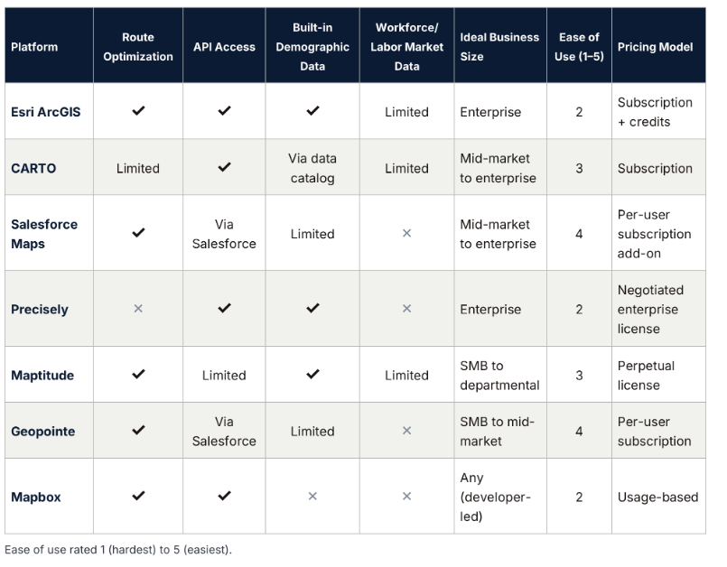
Three patterns stand out in this feature comparison.
First, ease of use and analytical depth trade off almost perfectly. The tools your recruiters and HR business partners could pick up quickly (Salesforce Maps, Geopointe) are the least capable of answering a site selection question. The tools that can answer it (ArcGIS, CARTO) need specialists.
Second, pricing models hide very different cost curves. A subscription is predictable. Usage-based pricing is cheap in a pilot and can climb sharply once an internal tool goes into production. Perpetual licenses look inexpensive until you account for data refreshes and upgrades. Integration capabilities drive costs too: every connector you build yourself is a maintenance liability.
Third, look at the workforce data column. Not one of these platforms treats labor market data as a first-class layer. Some can display census employment figures or education levels. None of them tell you how many qualified cloud security engineers live within commuting distance of a candidate site, what they earn, or how many other employers are competing for them.
The Missing Layer: Integrating Workforce Intelligence into Location Strategy
Here is a scenario we see often. A company shortlists three cities for a new operations center. The real estate team models rents. Finance models tax incentives. A consultant runs the geospatial analysis and produces a ranked list. Then talent acquisition is asked to hire 300 people in the winning city, and the problems surface: the specific skills are thin locally, the three largest employers in town have been hiring the same profiles for two years, and market pay sits well above the modeled bands.
Every one of those problems could have been identified before the decision, but the data wasn't in the model.
At Horsefly Analytics, we work from a simple premise: a location decision is a talent decision first. Labor is usually the largest ongoing cost of any new site, and the hardest constraint to fix after you commit. The factors that determine success are ones traditional location tools do not measure:
-
Talent availability: the actual supply of people with the required skills in a defined commuting area, not regional employment totals.
-
Skills density: how concentrated a capability is relative to the population, which signals whether you can scale hiring or will exhaust the pool after the first cohort.
-
Compensation benchmarks: what the market pays for each role in that location, so labor cost models reflect reality rather than a national average with a regional multiplier.
-
Competition for talent: which employers are recruiting the same profiles and how aggressively.
-
Diversity metrics: the composition of the local talent pool, which determines whether DEI commitments are achievable in a given market.
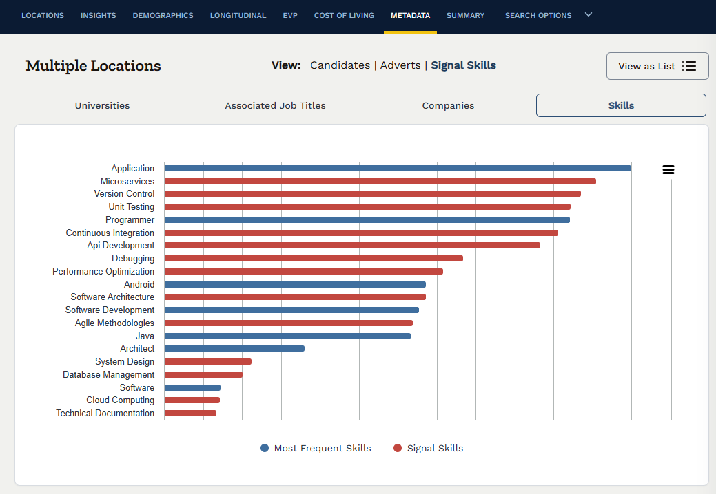
A view of Signal Skills to help understand the market from within the Horsefly platform
This is the shift from asking "where" to asking "who." Talent intelligence answers the second question with labor market data that can sit alongside the geospatial layers your real estate and finance teams already use. When both views inform the same decision, the shortlist often changes. A city that ranked third on real estate cost can rank first once you factor in time-to-hire and salary pressure.
Workforce intelligence also changes how talent acquisition operates after the site is chosen. Recruiting teams that know where the qualified candidates are, what they expect to earn, and who else is courting them set realistic hiring plans, target sourcing efficiently, and stop discovering compensation gaps through rejected offers.
The hard part is data quality. Labor market data comes from many sources of varying reliability, and fragmented inputs produce confident-looking but wrong answers. Our Horsefly Analytics platform is built to give workforce leaders a single, data-driven view of talent supply, cost, and competition across global markets, so location and talent decisions rest on the same evidence base.
A Framework for Choosing Your Location Planning Solution
Most failed software selections start with a demo rather than a requirement. This sequence prevents that.
-
Define the business decision you need to make. "Reduce shipping costs across our European network" and "find a nearshore talent pool for 500 finance roles" require different tools. Write down the three to five decisions the platform must support in the next 24 months. If most are talent-led, a route optimization engine is irrelevant to you.
-
Assess your data needs across three layers. Geospatial (boundaries, transport, points of interest), demographic (population, income, education), and workforce (talent supply, skills, compensation, competition). Map which layers each vendor provides natively, which you must license separately, and which you will have to source elsewhere. For global enterprises, check coverage country by country. Data that is excellent in the US and absent in Poland or the Philippines will not support a global footprint strategy.
-
Evaluate technical requirements and integration. Where does your data live? A cloud-native platform is the right fit if you run a modern warehouse and the wrong one if you do not. Confirm that the platform can ingest HRIS and ATS data, and ask for reference customers who have actually built those connections.
-
Calculate total cost of ownership, not the license cost. This is where most evaluations go wrong. License fees are often less than half of what you will spend. Include:
-
Third-party data licenses and annual refresh costs
-
Consumption charges (credits, API calls, map loads) at production volumes, not pilot volumes
-
Implementation and integration services
-
Internal headcount: a GIS analyst or data engineer to run the platform
-
Training, and retraining as staff turn over
-
The cost of the decisions the tool cannot support, which you will still pay consultants to answer
A platform with a modest subscription that requires a full-time specialist and separate workforce data can cost more than a pricier tool that covers your use cases out of the box.
-
Run a structured trial on a real decision. Use free trials and proofs of concept, but test them against a decision you have already made. Re-run your last site selection and see whether the platform would have surfaced the problems you encountered. If it would not have flagged the talent shortage that slowed your last expansion, it will not flag the next one.
-
Score against weighted selection criteria. Weight data quality and coverage highest, then fit to your defined decisions, then total cost of ownership, then ease of use. Involve the end users, including talent acquisition, not only the analytics team.
Understanding Growth with Data-Driven Location and Talent Decisions
The seven platforms reviewed here are strong at what they were built for. ArcGIS remains the benchmark for spatial depth, CARTO for cloud-scale analysis, Salesforce Maps and Geopointe for field teams, Precisely for data quality, Maptitude for value, and Mapbox for custom builds. Picking among them comes down to the decisions you need to make, the data you already have, and what the platform will cost you over three years rather than one.
For workforce leaders, though, the comparison matrix makes one point plain: the map is only half the model. A site that looks ideal on real estate and logistics can still fail if the talent is not there, costs more than planned, or is already being hired away by competitors. Combining geospatial analysis with workforce analytics is how you avoid choosing a location you cannot staff.
That combination is where we focus at Horsefly Analytics. If your next expansion, nearshoring plan, or hub consolidation depends on hiring the right people at the right cost, we would like to show you how our labor market data turns location shortlists into staffing plans you can defend in front of your CFO. Set up a strategic consultation with our team and bring a real location decision. We will show you what the talent data says about it.

Frequently Asked Questions
How does location planning software help businesses make strategic decisions?
Location planning software helps businesses make strategic decisions by integrating diverse data streams like demographics, foot traffic, and competitor locations onto a single map. This allows analysts to run scenarios, optimize operations, and test decisions quickly, improving site selection, logistics, and resource allocation.
What are the key capabilities to look for in location planning software?
Key capabilities include strong geospatial analysis for mapping and visualization, site selection tools for scoring candidate locations, logistics and mobility features for route optimization, and robust integration for connecting with existing business systems. Prioritize features matching your specific operational needs.
Why is workforce data often overlooked in traditional location planning tools?
Traditional location planning tools primarily focus on customer demand, assets, and routes, making them excellent for geospatial and demographic analysis. They are typically weaker at assessing talent availability, labor costs, and hiring competition, which are critical for successful long-term site operations.
How can integrating workforce intelligence improve business location decisions?
Integrating workforce intelligence improves location decisions by providing critical labor market data, such as actual talent supply, skills density, compensation benchmarks, and local competition. This ensures that staffing plans are realistic and sustainable, preventing costly hiring challenges after a site is chosen.
What is the best way to choose the right location planning software platform?
Begin by defining the specific business decisions the platform must support, then assess your data needs across geospatial, demographic, and workforce layers. Evaluate technical requirements, calculate the total cost of ownership beyond just license fees, and run a structured trial on a real decision.
What is the total cost of ownership for location planning software, beyond just subscription fees?
Total cost of ownership includes license fees, third-party data licenses, consumption charges for usage, and implementation services. Also factor in internal headcount for a GIS analyst or data engineer, training, and the potential cost of unanswered questions still requiring consultants.
What are common risks of choosing a business location without considering talent availability?
Without considering talent availability, businesses risk choosing a location where required skills are scarce, market pay exceeds budgets, or competition for talent is intense. This can lead to prolonged hiring delays, increased operational costs, and an inability to adequately staff the new site.
Sources: Horsefly Analytics